(This post details the rapidly accelerating Naval Arms Race between Burma and Bangladesh the neighbouring twos of the poorest nations on earth after their bitter maritime territorial disputes over the off-shore exploration and extraction of natural gas right on their disputed maritime border line.)
 |
| New F-22B Frigate of Bangladeshi Navy (2012). |
Population-exploding and slowly-sinking Bangladesh, one of the most poorest nations on this planet and the recipient of US$ 2 billion worth of international aid last year alone to feed its half-starving populace of 160 millions, has recently purchased two brand new Jiangwei II (053 H3) guided-missiles frigates from China at the cost of US$ 200 million each frigate.
The 324 ft (108 M) long frigate displaces 2,400 tons and carries 200 km range C-803 ship-to-ship guided missiles and 8.6 km range surface-to-air missiles. The brand-new missile frigates are newest additions to the two type 53H2 used-frigates already purchased from China. Bangladesh Navy was known to have six missile-capable frigates in 2008.
While Bangladesh has been steadily expanding its fleet of ship-destroying missile frigates the next door neighbor Burma is also quietly enlarging her fleet of Chinese frigates, armed with most powerfull ship-destroying missiles presently available in this world, from three to eight within few years as if it is competing with Bangladesh.
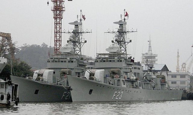 |
| Two Chinese used-frigates for Burma Navy (2011). |
Both Burma and Bangladesh are also building deadly Corvettes and Fast Attack Aircrafts capable of launching anti-ship guided missiles at each other’s ships. In my opinion Burma and Bangladesh the two poorest nations on this planet right now are in a very expensive naval arms race between them.
 |
| Design of new Bangladeshi missile Corvette. |
The extremely-heated issues propelling them into a very-expensive naval arms race is the maritime boundary issues worth tens of billions of dollar every year because of the rich natural gas deposits offshore in the disputed Bay of Bengal.
Off-shore Explorations and Territorial Dispute in 2008
Since late 1990s Burma has been successfully exploring, extracting, and selling natural gas to Thailand and China from the offshore wells in the Gulf of Martaban. And now they are extending their reach into the Bay of Bengal where the neighbor Bangladesh has been doing the same exact thing.
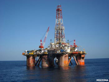 |
| A Transocean Drilling Rig. |
On November 2, 2008 the Bangladeshi government announced that the previous day its naval vessel BNS Nirvoy intercepted the Burmese naval ships escorting four drilling ships and a tug boat pulling the 100 meter long drilling rig Transocean Legend in the waters claimed by Dhaka.
Dhaka then urged Rangoon to immediately withdraw its ships and stop exploration until the sea boundary dispute is resolved as it would also refrain from exploration. It sent naval vessels to the disputed are but still vowed to use diplomatic methods to solve the dispute.
 |
| Bangladeshi frigate confronting Burmese oil rig (2008). |
The maritime boundary dispute was eventually brought to the International Tribunal for the Law of Sea, a UN Court situated in Germany, which fixes new maritime boundaries over disputed territorial claims between the neighboring nations.
 |
| Burma (53 million) is roughly 5 times bigger than crowded Bangladesh (160 million). |
Drawing the exact line of maritime boundary between two nations is an extremely complicated affairs and the UN Convention on The Law of The Sea itself has many key articles bordering on grey areas.
So whenever two nations were in dispute of the maritime boundaries both nations tried to refer whatever articles or precedence preferable for their advantage and the end result is never achieving an agreement and finally ending up at the UN’s International Tribunal For The Law Of The Sea (ITLOS).
Burma-Bangladesh maritime boundary dispute also ended that way. The dispute started in 1974 and an amiable agreement wasn’t reached till 2009 and the case ended up at the ITLOS in Germany.
The dispute is basically explained in following two figures where the red line is proposed by Burma and the green line is by Bangladesh. Please notice the fact that both lines are not straight as the Bangladesh’s St. Martin Island (Shin-ma-phyu Kyun) just 8 nautical miles from Burma’s coast line is right at the beginning of the boundary lines proposed by both Burma and Bangladesh.


And the just and fair and logical decision by the 21 independent and highly qualified and honorable judges is shown in the following figure. The black line between Burma’s red line and Bangladesh’s green line is the ITLOS’s final decision and the court’s ruling cannot be appealed.

The ITLOS has fixed the new maritime boundaries between Burma and Bangladesh that can be seen as a compromise to the decades-old dispute. “Both sides won something and lost something,” said Ruediger Wolfrum the German judge on the ITLOS panel of judges, according to German News Agency DPA.
A Bangladesh official said it was “A Victory for Both Sides,” as Dhaka and Rangoon could now begin to exploit the area for gas and oil. But Burma apparently was not that happy on the decision as Bangladesh has claimed 66,486 square miles and received 68,972 square miles. Even though the initially disputed area the Block AD-7 in the following figure clearly is now in the Burma's territory.

Military Build-up on Both Sides of the Border
Massive Military Built Up at Ann Pass, Arakan State, has been going on for many years now and accordingly that whole area on the Arakan Yoma at Ann has been restricted-area for the civilians. Ann airport was upgraded to Burma’s latest air force base. The Burmese Western Military Command Headquarters (Na-pa-kha) was relocated out from vulnerable Sittwe (Akyab) on the coastline to more-solidly defendable Ann.
Since the now-army-chief Min Aung Hlaing was the young CO of army Western Command (Na-pa-kha) in 2006 Burmese Army has been seriously preparing a very possible scenario of a border war with Bangladesh - after that serious threat issued by Saudi Crown Prince in April 1992 to invade our Arakan and give our fertile land to the half-starving millions of Bengali Muslims - and the army War Office has done whatever necessary for that inevitable border war.


The changes in the landscape in and around Ann (town and airfield) can be seen by comparing 2005 and 2006 satellite photos posted on Google Earth™. Note the circles in 2005 with no excavation on the slope of the hills.
(A) Military establishments have been further extended to the south of airfield and the original Ann town.

(B) On 2006 photo, hill slopes at two large hills had been excavated. Expansion of the establishments extended further south.

(C) Extended area from the hills to the west bank of Ann creek has been potted with standard military structures with blue colored roofs.

(D) Original Ann airport was upgraded with longer runway and new tarmac. The 2006 satellite photo was limited to see possible aircraft hangers, new taxi-ways, etc.

(E) Total population of original Ann town was 1,000. The town is spreading along the east bank of Ann Creek. The new military installations have been developed south and northeast of the old town. "Ann Creek" Hydropower Project is being implemented by the Ministry of Electric Power No. 1 on Ann Creek, 3.5 miles northeast to Ann. The project can generate 44 million kilowatt hours yearly when it is finished.

(F) Just on the western side of the hill across from the air base, more military installations have been establishing.
(G) The same way, more military installations have been developed on the east of original Ann town.

Finishing soon ………..